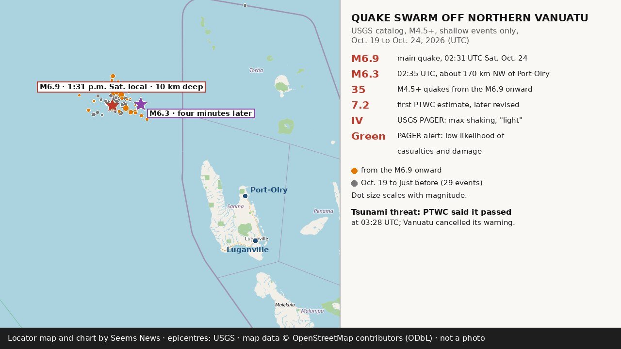
A magnitude 6.9 earthquake struck under the sea off northern Vanuatu on Saturday afternoon, Oct. 24, setting off a run of strong aftershocks that continued into Sunday, according to the U.S. Geological Survey. The USGS places the main quake at 02:31 UTC (1:31 p.m. in Vanuatu, or 7:31 p.m. Friday on the U.S. West Coast), about 197 kilometres west-northwest of Port-Olry, a village on the northern tip of the island of Espiritu Santo. The agency lists the depth at 10 kilometres, a value its catalog marks as operator-assigned, meaning seismologists fixed it rather than solving for it (USGS).
A second strong quake, magnitude 6.3, followed at 02:35 UTC, about four and a half minutes after the first and roughly 170 kilometres northwest of Port-Olry, per the USGS (USGS). Pacific Media Network describes the gap as four minutes; ABC News in Australia, in its summary, as five (PMN; ABC News). ABC News gives the time of the main quake as 12:31 p.m. AEST and its location as about 200 kilometres west of Sola, citing the USGS (ABC News).
About six minutes after the main shock, at 02:37 UTC, the Pacific Tsunami Warning Center in Honolulu issued its first threat message. Using a preliminary magnitude of 7.2, it said hazardous tsunami waves “are possible for coasts located within 300 km of the earthquake epicenter” and named Vanuatu as the only country in that zone, with an estimated arrival time of 03:01 UTC for Espiritu Santo (PTWC message 1). “Persons located in threatened coastal areas should stay alert for information and follow instructions from national and local authorities,” the center said, as ABC News also reported (PTWC; ABC News).
Japan’s Meteorological Agency, in a bulletin for the Northwest Pacific posted at 02:52 UTC and archived by the Global Disaster Alert and Coordination System, said it saw “a possibility of a destructive local tsunami near the epicenter” but expected no waves of 0.3 metres or more at any of its forecast points (GDACS archive of the JMA bulletin).
At 03:28 UTC, the warning center issued what it called its final statement. It revised the magnitude to 6.9 and said that, “based on all available data,” the tsunami threat from the earthquake “has now passed,” adding that “minor sea level fluctuations may occur in some coastal areas near the earthquake over the next few hours” (PTWC message 2). Vanuatu’s Geological Hazards Department then cancelled its own warning; in a statement on Facebook, the department said the latest sea-level observations confirm that coastal communities no longer face a tsunami threat, Pacific Media Network reports (PMN). This desk did not read the department’s Facebook post directly. Australia’s Bureau of Meteorology issued no threat for Australia, according to ABC News (ABC News).
The shaking did not stop with the first two quakes. A desk count of the USGS catalog, covering shallow quakes of magnitude 4.5 or greater in a box around the epicentres, finds 35 events from the magnitude 6.9 onward through 23:44 UTC Saturday, counting the 6.9 itself, 19 of them at magnitude 5 or greater (USGS catalog query). The strongest later shocks include magnitudes 5.7 and 5.8 at 04:05 and 04:12 UTC, another 5.8 at 05:23 UTC and a 5.9 at 08:56 UTC (7:56 p.m. local time). Pacific Media Network, which counts “more than 20 earthquakes” off northern Vanuatu since Saturday afternoon, reports tremors continuing overnight into Sunday (PMN). A separate magnitude 5.5 quake at 06:43 UTC, about 55 kilometres north-northeast of Port-Olry, struck far deeper, at about 195 kilometres, per the USGS catalog, and sits apart from the shallow cluster (USGS catalog query).
The swarm began days earlier. The same catalog shows a magnitude 6.0 quake in the area at 07:49 UTC on Monday, Oct. 19, and a magnitude 6.3 at 04:20 UTC on Tuesday, Oct. 20, for a total of 29 shallow quakes of magnitude 4.5 or greater, counting those two, before Saturday’s 6.9 (USGS, Oct. 19; USGS, Oct. 20; USGS catalog query). Pacific Media Network’s live updates describe the Tuesday quake once as magnitude 6.6 and once as magnitude 6.3 (PMN). The USGS catalog explains the gap: it lists a magnitude 6.3 moment-magnitude solution from the USGS alongside a separate magnitude 6.6 entry from the Pacific Tsunami Warning Center for the same moment (USGS catalog query).
So far, the impact on land looks limited. Pacific Media Network reports “no independently confirmed reports of significant damage or casualties,” while noting that the impact on the communities closest to the quakes “remains unclear” (PMN). The USGS’s automated PAGER loss model gives the main quake a green alert for both fatalities and economic losses, stating “There is a low likelihood of casualties and damage” (USGS PAGER). PAGER estimates that about 53,000 people live in areas exposed to intensity IV shaking, which the USGS scale calls light, and about 125 in areas exposed to intensity V; it places Luganville, a town of about 18,000 people in PAGER’s city list, at about intensity IV. The model also notes that the population of the region largely lives in structures highly vulnerable to shaking, though some resistant structures exist, and that recent quakes in the area have triggered landslides (USGS PAGER). The USGS public felt-report service, Did You Feel It?, had logged four reports for the main quake when this desk checked (USGS).
The automated figures above come from models and early readings; the USGS marks its PAGER and ShakeMap products for this quake as automatic, and both may change as seismologists review the data (USGS). This page will not track later revisions in real time; readers can follow the USGS event page and Vanuatu’s Geological Hazards Department for updates.