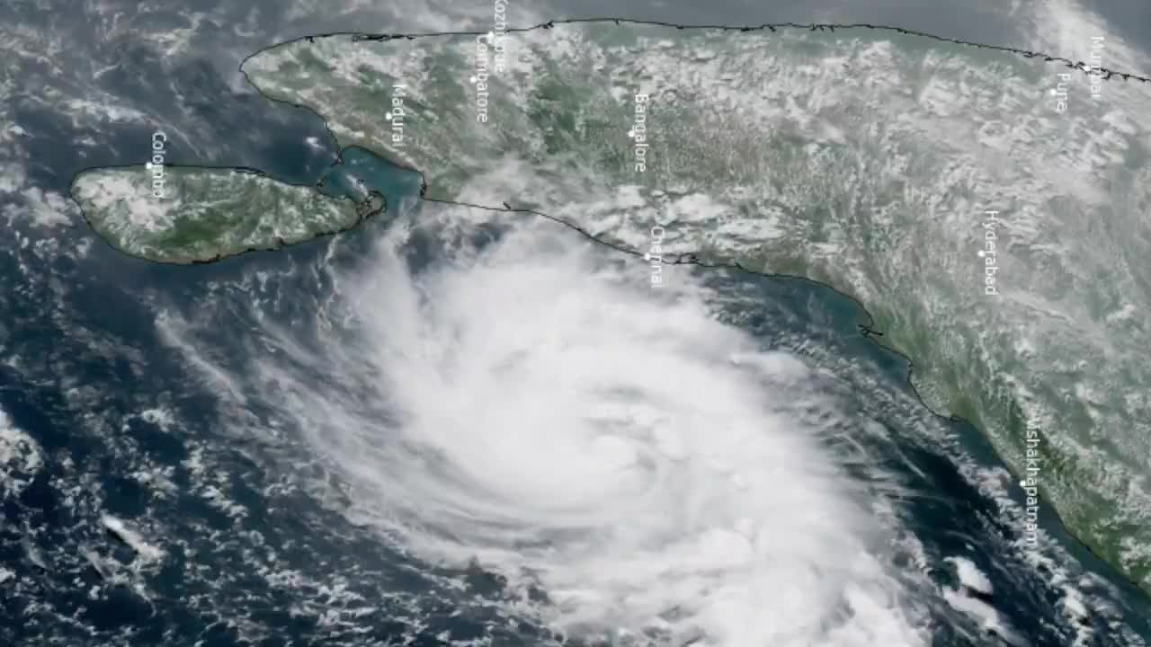
A new cyclone formed over the Bay of Bengal on Sunday, Nov. 1, and headed for India’s Andhra Pradesh coast, less than a week after Cyclone Arnab struck the same state, according to the India Meteorological Department (IMD) and Indian news reports. IMD said in a post on X that a deep depression intensified into the Cyclonic Storm “Murasu” at 11:30 a.m. India time (10 p.m. Saturday, PT) about 560 km east-southeast of Chennai. The name means “war drum” in Tamil, according to The Hindu.
By 2:30 p.m. India time the storm had moved west-northwest at 27 kmph over the previous six hours and sat near 12.4°N, 84.6°E, about 480 km east-southeast of Chennai, 550 km east-southeast of Nellore, 560 km southeast of Machilipatnam and 610 km south-southeast of Visakhapatnam, according to IMD’s Tropical Cyclone Advisory No. 1, issued at 5:30 p.m. India time and signed by Dr. Akhil Srivastava of the agency’s Regional Specialised Meteorological Centre in New Delhi. The same bulletin went out as a “Red Message” warning on X. Earlier reports, including one by India Today, cited a speed of 23 kmph; that figure came from IMD’s 11:30 a.m. bulletin, not the later one.
What the forecast says. IMD expects Murasu to strengthen into a severe cyclonic storm over the west-central Bay of Bengal around Monday morning, then turn northwest and cross the south Andhra Pradesh coast between Nellore and Narsapur from about 11:30 p.m. Monday to 4 a.m. Tuesday, India time, with sustained winds of 100–110 kmph gusting to 120 kmph, according to the advisory. In PT, that window runs from 10 a.m. to 2:30 p.m. Monday, Nov. 2. The advisory’s forecast table shows the storm weakening to a cyclonic storm by Tuesday morning, a deep depression by late Tuesday and a depression by Wednesday morning, India time.
The bulletin rates confidence in the track as high and in the intensity forecast as moderate to high. It also lays out where the computer models disagree: the European ECMWF model, its AI counterpart EC-AIFS and Google DeepMind’s model show a severe cyclonic storm at landfall; the U.S. GFS model, the Aurora AI model and several others show a weaker cyclonic storm; and IMD’s own multi-model ensemble, the NCUM-R regional model and the Pangu and GraphCast AI models show only a deep depression (advisory). IMD puts sea-surface temperatures across the Bay of Bengal near 29°C, about one degree lower than the week before, and lists those warm waters, low wind shear and moist mid-level air as conditions that support strengthening.
Watch: the storm from space, and the coast, via posts on X
If an embed does not load, it shows as a plain link to the original post.
View the @chennaisweather post on X
View the @DeccanChronicle post on X
The forecast firmed up over the day. Earlier on Sunday, before the storm got its name, IMD Director General Mrutyunjay Mohapatra told a virtual press conference, “At present, we expect this to form into a cyclonic storm. Once formed, it will be named as Murasu. There is a slight possibility it may turn into a severe cyclonic storm too, but at present, our forecast is for a cyclonic storm, which should hit the Andhra coastline on the morning of November 3,” according to Hindustan Times. The later advisory names a severe cyclonic storm as the most likely outcome.
Storm surge and rain. The advisory warns of a storm surge of 1.0 to 1.5 metres above the astronomical tide that could inundate low-lying coastal areas of Bapatla, Guntur, Krishna and Prakasam districts around landfall. A Hindustan Times live-blog headline describes a “2-metre storm surge”; this desk could not find that figure in IMD’s advisory and reports IMD’s range. Andhra Pradesh officials expect 20 mandals (sub-districts) to get extremely heavy rain — nine in Eluru district, five each in Krishna and NTR and one in Bapatla — with district averages for Nov. 3 forecast at 179 mm in Eluru, 163 mm in Krishna and 161 mm in NTR, according to the New Indian Express.
The Hindu reports that the state sounded a red alert for Nov. 2 in Krishna, Guntur, Bapatla, Prakasam and Sri Potti Sriramulu Nellore districts, with gusty winds of 80 to 90 kmph, and a red alert for districts along the Telangana border for Nov. 3. In Tamil Nadu, the Regional Meteorological Centre in Chennai forecast heavy to very heavy rain at isolated places in Tiruvallur district through 8:30 a.m. Monday and in Chennai and Tiruvallur districts over the following 24 hours, according to a second Hindu report.
A state still cleaning up from Arnab. Murasu bears down on a coast that Cyclone Arnab, a very severe cyclonic storm, hit near Narsapur in West Godavari district on Oct. 28 with gusts of up to 150 kmph, according to The Hindu. The paper reports that Arnab killed five people, submerged crops on more than 3.5 lakh (350,000) hectares, damaged 2,425 km of roads and brought down about 15,000 power poles, with state losses put at ₹4,600 crore (₹46 billion). The New Indian Express reports seven deaths from Arnab; this desk could not reconcile the two tolls and reports both. Seems News covered Arnab’s landfall here.
Chief Minister N. Chandrababu Naidu said in an official press release, “Another cyclone is approaching Andhra Pradesh and officials must remain fully prepared to undertake relief and rescue operations, as a severe cyclonic storm is expected to cross the coast near Bapatla on the morning of November 3,” according to the New Indian Express. The paper reports that Naidu ordered bulletins every four hours, said telecom operators could have taken more precautions to prevent network outages during Arnab, and cancelled a planned Monday visit to Delhi, which his office announced in a post on X. State officials place landfall near Bapatla, a point inside IMD’s broader Nellore–Narsapur window.
Odisha and Tamil Nadu. In neighbouring Odisha, also hit by Arnab, Disaster Management Minister Suresh Pujari said the government had ordered the evacuation of people from low-lying areas and hilly terrain, according to the New Indian Express. India Today reports that officials told block-level staff to prepare micro-plans and move people in high-risk spots to shelters by Sunday night, advised fishermen not to go to sea from Nov. 2 to Nov. 4 and put National Disaster Response Force and Odisha Disaster Rapid Action Force teams on standby. Manorama Mohanty, director of IMD’s Bhubaneswar centre, said rain would reach Odisha from Nov. 2 and grow heavier on Nov. 3 and 4, the New Indian Express reports.
Odisha still faces flooding from the earlier storm: Ganjam district collector V. Keerthi Vasan said officials had evacuated 56,051 people to 367 shelters and about 700 remained stranded in waterlogged areas after Arnab, according to Hindustan Times. That figure refers to Arnab, not Murasu.
What remains uncertain. The advisory gives a landfall window rather than a single point, and its models split on whether Murasu reaches severe strength. IMD issues updated advisories through the day; the next ones may shift the track, timing or strength. This desk will not report casualty or damage figures from Murasu until officials publish them.
Seems News could not reach IMD or state officials for this report and relies on IMD’s advisory and posts on X and the outlets named above. This desk read the advisory in full from IMD’s website; quotes from news reports appear as those outlets published them.