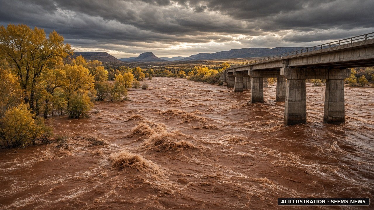
The San Juan River at Farmington, N.M., has climbed higher than at any time in its recorded history, the National Weather Service says, and overnight the high water moved downstream toward Shiprock on the Navajo Nation. In a flood statement issued at 11:31 p.m. MDT Friday, the agency’s Albuquerque office wrote: “Major flooding continues, though the river has likely crested and will slowly fall. This is the flood of record.” It compared this crest with “a previous crest of 12.3 feet on 09/06/1909” (NWS).
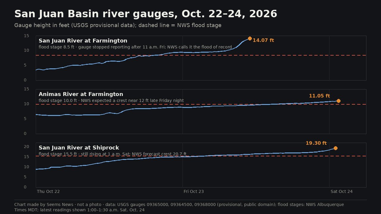
The exact peak at Farmington may never appear on a chart. The U.S. Geological Survey gauge on the river recorded 14.07 feet at 11 a.m. MDT Friday, more than five feet above the 8.5-foot flood stage, and then went silent (USGS). A weather service statement issued at 6:39 p.m. MDT Friday noted that after that reading “the river gage was no longer operational” (NWS). By late Friday the agency listed the current stage as missing and forecast the river to fall below flood stage Saturday afternoon, sinking to about 3.1 feet by Wednesday evening (NWS). By that reading, the worst at Farmington seems to have passed, though nobody measured the top of the crest.
“The San Juan River is rising quickly in Shiprock, NM. The river is forecast to crest at 17.6 feet Friday evening before falling below flood stage late Saturday night. Officials are urging those along the river to EVACUATE NOW. A shelter is open at McGee Park. #NMwx” — Grant Tosterud (@granttosterudwx) (October 23, 2026)
“Look at the power of this water! The Navajo Police Department shared video showing the swollen San Juan River near Mexican Hat, Utah, Friday evening.” — Heidi Hatch KUTV (@tvheidihatch) (October 24, 2026)
Farmington sits where the Animas River meets the San Juan, and the Animas rose too. Its gauge in town read 11.05 feet at 1:30 a.m. MDT Saturday, above the 10-foot flood stage (USGS). The weather service warned that at 12 feet “the riverwalk area in Farmington is flooded and should be avoided,” and added: “Water levels have not been this high since the flood of 1927.” It expected the Animas to crest around 12 feet overnight and to drop below flood stage Saturday evening, with “additional rises” possible after that (NWS).
The danger now seems to shift west. Downstream at Shiprock, the USGS gauge climbed from 17.33 feet at 10 p.m. Friday to 19.30 feet at 1 a.m. Saturday, MDT (USGS). The weather service forecast major flooding there, with a crest of 20.7 feet “late tomorrow morning” — Saturday — before the river falls below its 15.5-foot flood stage early Sunday (NWS). Shiprock Vice President Debra Yazzie and Navajo Nation President Buu Nygren posted an urgent evacuation alert on Facebook for families along the river, according to ICT, and named the Diné Christian Center as a shelter for up to 200 people (ICT). The Albuquerque Journal reports that First Baptist Church and Power House Church in Shiprock also took in displaced residents (Albuquerque Journal). The La Plata River below Redmesa, another stream the weather service tracks for San Juan County, neared its own record; the agency said moderate flooding there “approaches the flood of record” set in 1934 (NWS).
On the ground in San Juan County, Friday brought rooftop rescues and a stream of evacuation orders. Farmington Police Chief Steve Hebbe told reporters: “This is a once-in-a-generation time. This is singular and this is real. So far, we have not had any deaths but this is not anything that should be played with” (KOB 4). He also urged residents: “Listen to evacuation orders and leave those neighborhoods before your life is on the line” (Tri-City Record). County spokesman Devin Neeley estimated about 60 rescue operations by Friday evening, telling the Albuquerque Journal, “The focus is on getting people out, not taking a head count” (Albuquerque Journal).
The floodwater carries a second hazard. Flooding forced the City of Bloomfield, east of Farmington, to shut down its water reclamation facility, and authorities said “the San Juan River is a hazmat situation” because untreated wastewater has entered it, KOB reports (KOB 4). KOAT says officials told residents to consider that floodwaters may hold raw sewage (KOAT). Bloomfield asked residents to conserve water, the Albuquerque Journal reports, and Mayor John Mohler urged people to limit wastewater discharge until the plant “can safely resume operations,” according to KOB (Albuquerque Journal; KOB 4). KOB also reports “over 3,000 electrical outages” in the county, and the American Red Cross set up a shelter at McGee Park in Farmington, according to the Albuquerque Journal, where KOAT says pets and RVs may come too (KOB 4; Albuquerque Journal; KOAT).
The New Mexico flooding forms one piece of a wider storm across the Four Corners. Colorado Gov. Jared Polis declared disaster emergencies for 11 counties and authorized National Guard help with rescues in southwest Colorado, NPR reports; in Pagosa Springs, Colo., the San Juan crested Friday morning at 15.02 feet, the second-highest crest on record there, according to KOB (NPR; KOB 4). In Dennehotso, Ariz., the Navajo Department of Emergency Management reported rescuing seven families, 30 people, from flooded homes, and in Utah the City of Hurricane declared an emergency after flooding damaged more than 100 homes and RVs (KUNR; NPR).
Kris Sanders, a meteorologist at the weather service in Grand Junction, Colo., told NPR that the remnants of Hurricane Trudy formed a slow-moving low-pressure system that brought the rain, and that parts of southwest Colorado and southeast Utah got two to four inches, with up to six inches in the San Juan Mountains, and said: “Those rainfall amounts are records in themselves.” He added that thunderstorm watches remain active in many of the same areas through Sunday (NPR). Climate scientist Daniel Swain told NPR that moisture from record-warm waters off the West Coast, driven by a strong El Niño and a marine heat wave, fed the storms (NPR).
Some numbers still seem unsettled. Reports of how many people left their homes run from about 30 people to 600 people or 600 households to roughly 1,500 residences, depending on the source, the area counted and the hour (KOB 4; KUNR; Albuquerque Journal). The Albuquerque Journal also gives gauge heights of 23.17 feet at Shiprock and 14.5 feet near Farmington, figures this desk could not match to the USGS readings or weather service statements it checked (Albuquerque Journal). USGS labels all its recent gauge data provisional and subject to revision.
This desk read five NWS Albuquerque flood statements issued late Friday through the weather service’s public data service, pulled USGS readings for the three gauges in the chart, and read reports from NPR, KOB 4, KUNR, KOAT, the Albuquerque Journal, the Tri-City Record and ICT. The weather service planned its next river statements for Saturday afternoon. The chart above shows USGS data and contains no photo.