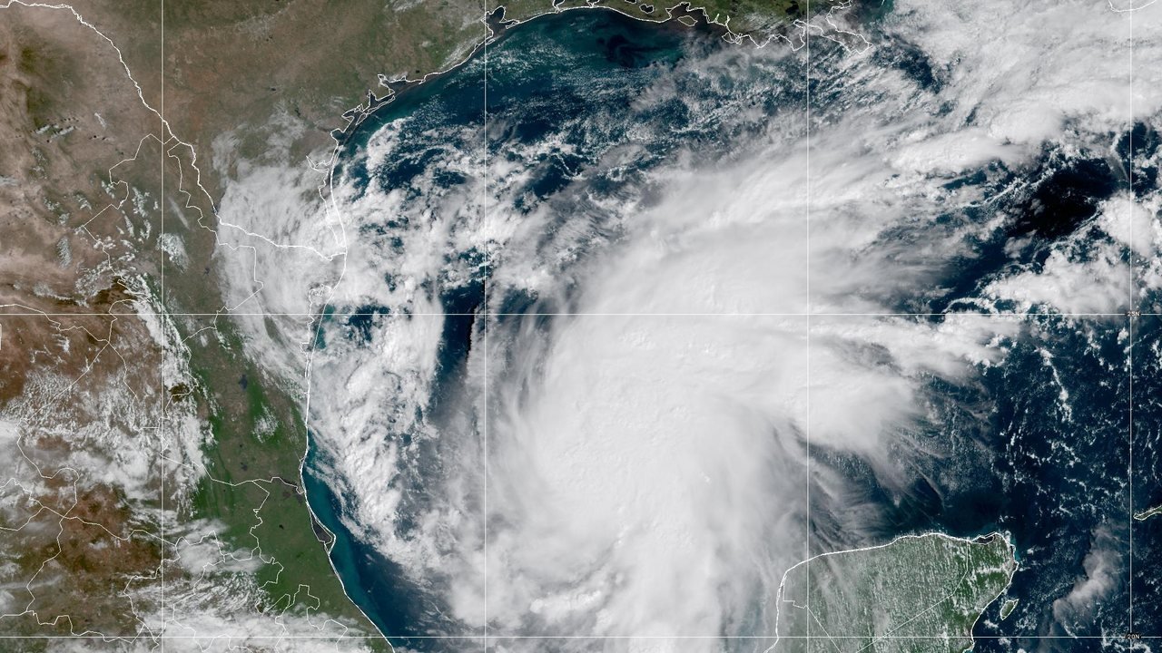
The Atlantic hurricane season seems to have found its first real threat with less than two months left on the calendar. Tropical Storm Isaias grew out of Tropical Depression Nine in the southern Gulf of Mexico on Wednesday, October 7, and by 10 a.m. CDT (8 a.m. PT) the National Hurricane Center (NHC) had raised its top sustained winds to near 45 mph and issued hurricane and storm surge watches for the northern Gulf Coast. Isaias ranks as the ninth named storm of the 2026 Atlantic season, CBS News reports, and forecasters expect it to become the first one to reach hurricane strength.
When the 10 a.m. advisory went out, an Air Force Reserve Hurricane Hunter aircraft had fixed the center near 22.4 degrees north and 93.6 degrees west, about 260 miles west-northwest of Progreso, Mexico, and about 540 miles south-southwest of the mouth of the Mississippi River. The storm crept east-northeast at about 8 mph, and tropical-storm-force winds reached up to 45 miles from its center. Dropsondes, instruments that the crew drops through the storm, measured a central pressure of 1000 millibars, a 4-millibar fall that helped persuade forecasters the storm had strengthened.
The NHC forecast calls for a quick climb. In its discussion, forecaster Blake wrote that the storm’s low- and mid-level centers appear to line up better after the center re-formed a bit to the north, a structural change that could allow rapid intensification over the next day or two, with light-to-moderate wind shear, “near-record SSTs for this time of the year,” meaning sea surface temperatures, and a very moist environment. The official track bends Isaias north of the Yucatan Peninsula on Thursday and then north toward the coast. The forecast puts top winds at 75 mph by early Thursday, Pacific time, 90 mph by Thursday evening, and 110 mph by early Friday, the high end of Category 2, then 105 mph by Friday evening as the center nears the coast between Mobile Bay and the Florida Panhandle. By early Saturday the forecast moves the center inland over western Alabama with winds down to about 50 mph. The NHC’s first key message warns of an “increasing risk of life-threatening storm surge along portions of the northern Gulf coast” and predicts a strong hurricane by the time Isaias nears land on Friday.
The watches stretch across four states. A Hurricane Watch covers Bay St. Louis, Mississippi, to Indian Pass, Florida, which takes in the Mississippi coast, Mobile, Pensacola, and Panama City. A Tropical Storm Watch extends west to the Jefferson and Plaquemines Parish line in Louisiana and east to the Aucilla River in Florida’s Big Bend. A Storm Surge Watch runs from the mouth of the Mississippi River all the way to Yankeetown, Florida. The hurricane center says hurricane conditions could begin in the watch area late Friday, with tropical-storm-force winds arriving around midday Friday, and it warns that more watches and warnings could follow later Wednesday.
Water poses the biggest danger. If peak surge arrives at high tide, the NHC says, water could reach 5 to 7 feet above ground from Ocean Springs, Mississippi, to Indian Pass, Florida, including Mobile Bay, and 3 to 5 feet from the mouth of the Mississippi to Ocean Springs and from Indian Pass to the Aucilla River. Lake Pontchartrain could see 1 to 3 feet. “Residents in the watch area should follow advice given by local officials and evacuate if told to do so,” the center’s key messages say. For the hurricane watch area, the advice reads, “Residents in these areas should prepare for the possibility of long-duration power outages.” Rain adds a second threat: the NHC forecasts 3 to 6 inches, with local totals up to 10 inches, from far southeastern Louisiana to the Florida Panhandle from Friday through the weekend, and 1 to 3 inches, locally up to 5, across much of the Southeast as far north as the Tennessee Valley and the Carolinas, enough for flash and urban flooding and isolated river flooding. Mexico gets the first taste, with 2 to 4 inches of rain forecast along the Bay of Campeche through Thursday.
Officials have started to move. Florida Gov. Ron DeSantis signed an executive order on Tuesday declaring a state of emergency for 25 counties, CBS News and the BBC report. DeSantis said the order “ensures communities have the time and resources necessary to prepare for potential severe weather impacts to the Panhandle and Big Bend region of Florida,” according to CBS News. The desk found no similar declarations from Alabama, Mississippi, or Louisiana by Wednesday morning, though local officials there may act as the watches turn into warnings.
The forecast still carries real uncertainty. Blake wrote that the model guidance still splits, with AI-based weather models generally on the eastern side of the spread and traditional physics-based models on the western side. The NHC nudged its track a bit east but stopped short of a consensus aid and of Google DeepMind’s ensemble mean, both of which lean farther east. Many of the stronger model runs sit on the faster, eastern half of the guidance, he added, which led forecasters to issue watches over a wide stretch of coast. Near landfall, rising wind shear could weaken the storm somewhat, though the discussion says the rate of weakening remains unclear, and Isaias should grow in size as it meets a trough over the northwestern Gulf coast. The BBC, citing the NHC, expects Category 2 strength by Friday morning and landfall in Louisiana, Mississippi, Alabama, or Florida late Friday or early Saturday.
Isaias would break a strange streak. Through the end of September, no hurricane formed anywhere in the North Atlantic, which the BBC describes as the first such September in more than 30 years and the latest date without a hurricane in the satellite era, which began in the 1960s. Four tropical storms formed in September, Edouard, Fay, Gonzalo, and Hanna, but none reached hurricane strength. Forecasters blame a developing El Niño that the BBC calls the strongest on record for this point in its cycle. El Niño raises upper-level winds over the Caribbean and Atlantic, and that wind shear tears thunderstorms apart before they can organize. The same pattern has fueled a very busy eastern Pacific season, with 17 named storms there, nine of them hurricanes, by the BBC’s early-October count. Isaias found a pocket of low shear and Gulf water of about 30 to 31 degrees Celsius, roughly 86 to 88 degrees Fahrenheit, the BBC reports, and that warm water gives it the fuel to grow.
The name carries history too. Isaias took the slot on the rotating Atlantic list after forecasters retired Ike following the 2008 season, CBS News notes, and the “I” storms have produced some of the most destructive hurricanes in recent memory, including Ian, Ida, Irma, and Irene. The next full NHC advisory comes at 4 p.m. CDT (2 p.m. PT), with an intermediate update at 1 p.m. CDT (11 a.m. PT). Anyone along the northern Gulf Coast should take forecasts from the NHC and local National Weather Service offices, not from this desk, and follow local evacuation orders.